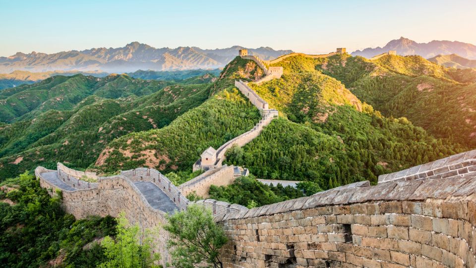
Journey across Great Wall of China and discover the story behind one of the most impressive structures ever built. Students will explore how different sections of the wall were constructed over centuries, why rulers believed it was important for protection and defense, and what it reveals about power, leadership, and human determination.
This Kahoot examines the history and engineering of the Great Wall, including the materials used to build it, the soldiers and workers who maintained it, and the challenges of constructing such a massive structure across mountains and deserts. Students will also discover why the wall became one of the New Seven Wonders of the World and remains one of the world’s most recognizable landmarks.
Ideal for lessons on history, geography, engineering, and world cultures, this Kahoot encourages students to explore the lasting legacy of ancient Chinese civilization and one of humanity’s greatest building achievements.
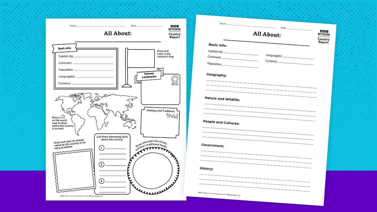
Turn your classroom into a global exploration hub! This country report template invites students in Grades 3–8 to become curious investigators — uncovering what makes each country unique and sharing their discoveries in creative ways.
Designed with flexibility in mind, the resource includes two approachable formats:
- Snapshot Style: A lively, visual option that’s perfect for quick learning or younger students. Learners can sketch, label, and highlight key features — like flags, landmarks, foods, and traditions — while building confidence with short responses.
- Explorer Style: A more in-depth format for students ready to dig deeper. It guides learners through topics such as geography, wildlife, culture, and history, helping them organize ideas and develop clear, informative writing.
Best of all, this template pairs seamlessly with BBC videos — bringing countries to life through real-world sights, sounds, and stories. Students can watch, wonder, and then weave what they’ve learned into their own reports.
Quick Teacher Tips: Use country studies as a springboard into wider learning across subjects:
- Geography: Map skills, climate zones, landforms, and ecosystems
- Language Arts: Informational writing, summarizing, note-taking, and presenting
- History: Key events, timelines, and how the past shapes the present
- Math: Population comparisons, distances, currency conversions
- Arts & Culture: Traditional patterns, music, celebrations, and food
- Current Events: Tie in informational reading and media literacy by exploring what’s happening in that country today in an age-appropriate way.

Dive into the wonders of Antarctica with this multi-grade lesson collection! Tailored for K–2, 3–5, 6–8, and 9–12, each unit includes engaging activities, thought-provoking discussions, and hands-on projects to uncover the mysteries of the frozen continent. Enhance your teaching with stunning BBC video clips showcasing Antarctic wildlife, research stations, and breathtaking icy landscapes. Printable resources like animal fact sheets, scientist journal templates, and conservation challenges bring the learning to life for your students. Perfect for science, geography, and environmental lessons!
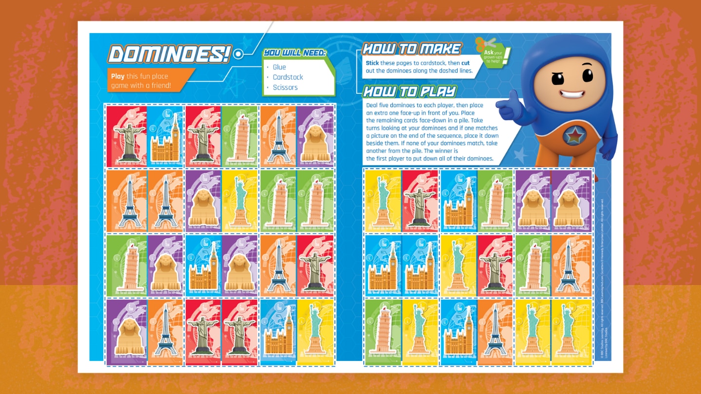
Play this fun Go Jetters dominoes game (featuring famous world landmarks) with a friend! Here's how to play:
- Deal five dominoes to each player, then place an extra one face-up in front of you.
- Place the remaining cards face-down in a pile.
- Take turns looking at your dominoes and if one matches a picture on the end of the sequence, place it down beside them. If none of your dominoes match, take another from the pile.
- The winner is the first player to put down all of their dominoes.
In What Is Developmental Topographical Disorientation, meet Anne, a woman with a condition that makes it difficult for her to orient herself in space, even in familiar environments. Anne’s struggle to form mental maps of her surroundings affects her daily life and employment. This condition, which is only recently being studied, involves a person becoming disoriented without brain damage. Learn about how people typically develop mental maps and how Anne’s experience is challenging for both her and the medical team. This video is excerpted from BBC’s The World’s Most Extraordinary People, a documentary series revealing how rare medical conditions inspire groundbreaking scientific discoveries.
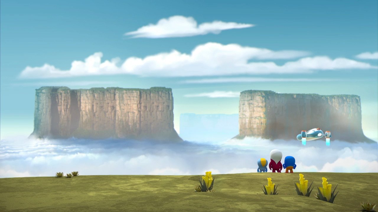
In The Go Jetters Climb the Tepui Mountains of Venezuela, the Go Jetters crew is in Venezuela and climbs to the top of a tepui, an extraordinary rock formation. Ubercorn shares funky facts about tepuis, including how they are older than dinosaurs and home to unique plant life. This video is excerpted from BBC’s Go Jetters, a series that follows the adventures of four international heroes as they travel the globe visiting landmarks and solving environmental problems with Ubercorn, a disco-dancing unicorn.
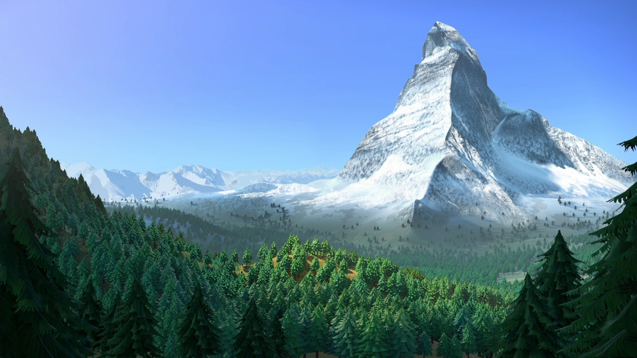
In The Go Jetters Mount the Matterhorn, the Go Jetters crew learns about the Matterhorn, a mountain that straddles Switzerland and Italy. Ubercorn shares funky facts about the mountain’s height, position, and cloud formations. This video is excerpted from BBC’s Go Jetters, a series that follows the adventures of four international heroes as they travel the globe visiting landmarks and solving environmental problems with Ubercorn, a disco-dancing unicorn.
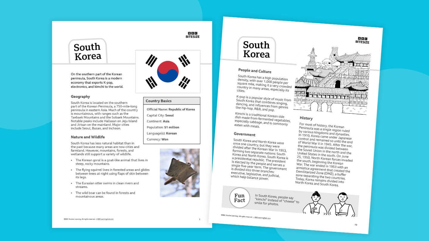
Explore the culture, history, and modern life of South Korea with this student-friendly fact file for Grades 3–8. Students will explore South Korea’s geography, history, culture, wildlife, and government while learning about mountain landscapes, Korean traditions, K-pop, kimchi, important events in Korean history, and the country’s modern economy and technology.
You can use this fact file to:
- Introduce a geography or social studies unit
- Support nonfiction reading practice
- Compare countries and cultures
- Complete map and research activities
- Prepare students for projects or presentations (use our country report template!)
- Pair with videos, articles, or other informational texts (see Related Resources below)
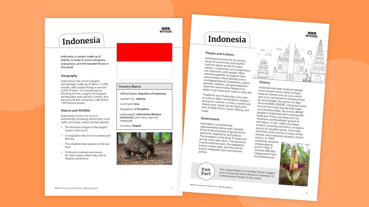
Travel across the islands of Indonesia with this colorful one-page fact file for Grades 3–8. Students will explore Indonesia’s geography, history, culture, wildlife, and government while learning about thousands of islands, volcanoes and coral reefs, tropical rainforests, unique animals such as Komodo dragons and orangutans, and the traditions of Indonesia’s many cultures.
You can use this fact file to:
- Introduce a geography or social studies unit
- Support nonfiction reading practice
- Compare countries and cultures
- Complete map and research activities
- Prepare students for projects or presentations (use our country report template!)
- Pair with videos, articles, or other informational texts (see Related Resources below)
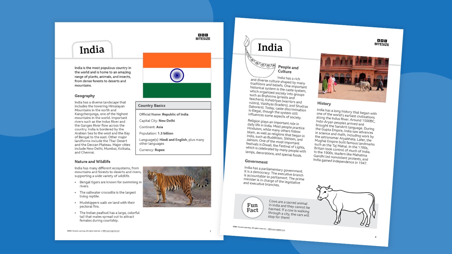
Introduce students to the rich cultures, landscapes, and history of India with this classroom-ready fact file for Grades 3–8. Students will explore India’s geography, history, culture, wildlife, and government while learning about the Himalayan Mountains, major rivers, diverse religions and traditions, colorful festivals, and animals such as Bengal tigers and Indian peafowl.
You can use this fact file to:
- Introduce a geography or social studies unit
- Support nonfiction reading practice
- Compare countries and cultures
- Complete map and research activities
- Prepare students for projects or presentations (use our country report template!)
- Pair with videos, articles, or other informational texts (see Related Resources below)
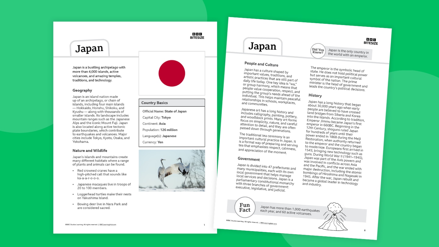
Discover the islands, traditions, and history of Japan with this one-page fact file for Grades 3–8. Students will explore Japan’s geography, history, culture, wildlife, and government while learning about volcanic islands, mountain landscapes, traditional customs, unique wildlife, modern cities, and important moments from Japan’s past and present.
You can use this fact file to:
- Introduce a geography or social studies unit
- Support nonfiction reading practice
- Compare countries and cultures
- Complete map and research activities
- Prepare students for projects or presentations (use our country report template!)
- Pair with videos, articles, or other informational texts (see Related Resources below)
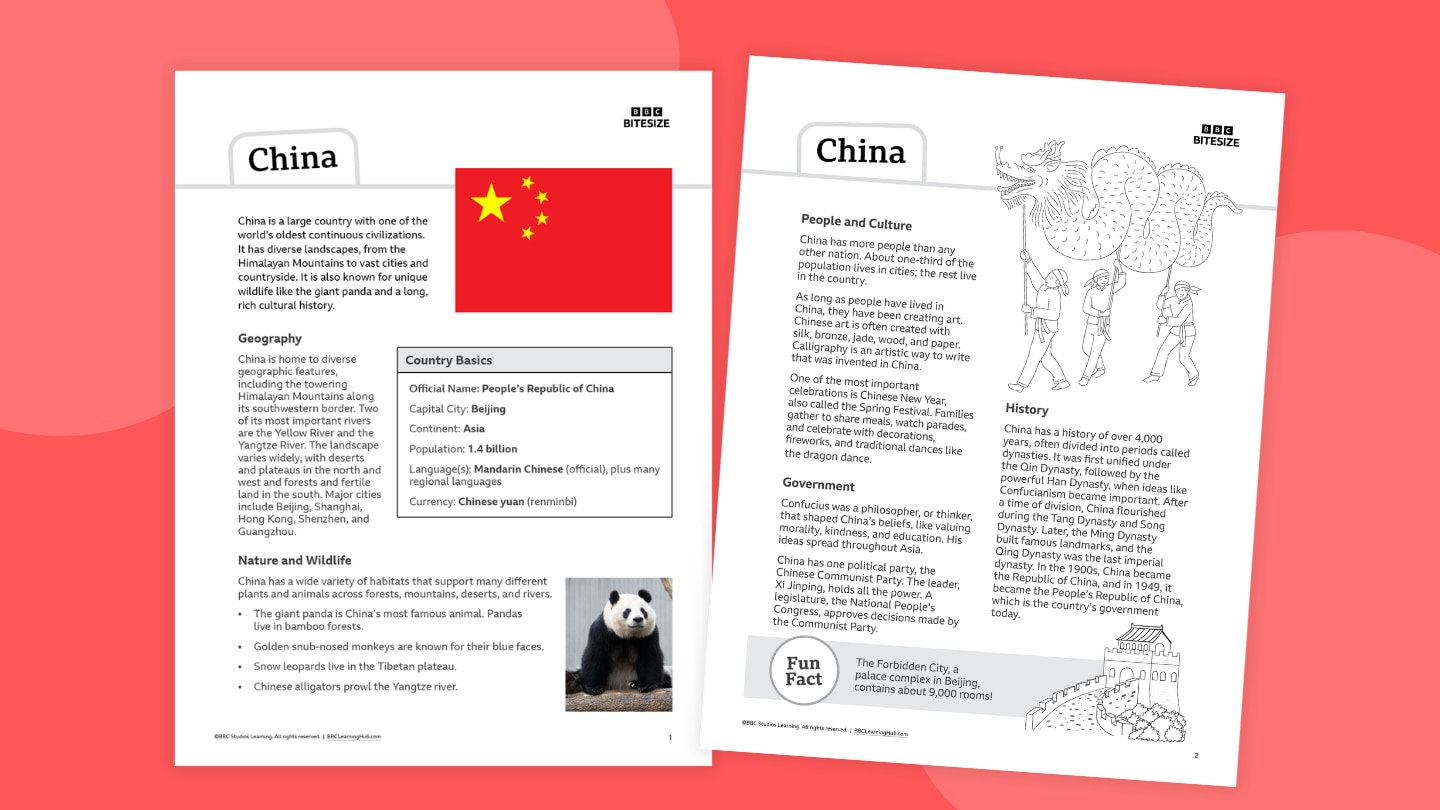
Take students on a journey through China with this engaging one-page fact file for Grades 3–8. Students will explore China’s geography, history, culture, wildlife, and government while learning about famous mountains and rivers, bustling cities, giant pandas, traditional celebrations such as Chinese New Year, and important moments from China’s long history.
You can use this fact file to:
- Introduce a geography or social studies unit
- Support nonfiction reading practice
- Compare countries and cultures
- Complete map and research activities
- Prepare students for projects or presentations (use our country report template!)
- Pair with videos, articles, or other informational texts (see Related Resources below)
Journey across Great Wall of China and discover the story behind one of the most impressive structures ever built. Students will explore how different sections of the wall were constructed over centuries, why rulers believed it was important for protection and defense, and what it reveals about power, leadership, and human determination.
This Kahoot examines the history and engineering of the Great Wall, including the materials used to build it, the soldiers and workers who maintained it, and the challenges of constructing such a massive structure across mountains and deserts. Students will also discover why the wall became one of the New Seven Wonders of the World and remains one of the world’s most recognizable landmarks.
Ideal for lessons on history, geography, engineering, and world cultures, this Kahoot encourages students to explore the lasting legacy of ancient Chinese civilization and one of humanity’s greatest building achievements.
Turn your classroom into a global exploration hub! This country report template invites students in Grades 3–8 to become curious investigators — uncovering what makes each country unique and sharing their discoveries in creative ways.
Designed with flexibility in mind, the resource includes two approachable formats:
- Snapshot Style: A lively, visual option that’s perfect for quick learning or younger students. Learners can sketch, label, and highlight key features — like flags, landmarks, foods, and traditions — while building confidence with short responses.
- Explorer Style: A more in-depth format for students ready to dig deeper. It guides learners through topics such as geography, wildlife, culture, and history, helping them organize ideas and develop clear, informative writing.
Best of all, this template pairs seamlessly with BBC videos — bringing countries to life through real-world sights, sounds, and stories. Students can watch, wonder, and then weave what they’ve learned into their own reports.
Quick Teacher Tips: Use country studies as a springboard into wider learning across subjects:
- Geography: Map skills, climate zones, landforms, and ecosystems
- Language Arts: Informational writing, summarizing, note-taking, and presenting
- History: Key events, timelines, and how the past shapes the present
- Math: Population comparisons, distances, currency conversions
- Arts & Culture: Traditional patterns, music, celebrations, and food
- Current Events: Tie in informational reading and media literacy by exploring what’s happening in that country today in an age-appropriate way.
Dive into the wonders of Antarctica with this multi-grade lesson collection! Tailored for K–2, 3–5, 6–8, and 9–12, each unit includes engaging activities, thought-provoking discussions, and hands-on projects to uncover the mysteries of the frozen continent. Enhance your teaching with stunning BBC video clips showcasing Antarctic wildlife, research stations, and breathtaking icy landscapes. Printable resources like animal fact sheets, scientist journal templates, and conservation challenges bring the learning to life for your students. Perfect for science, geography, and environmental lessons!
Play this fun Go Jetters dominoes game (featuring famous world landmarks) with a friend! Here's how to play:
- Deal five dominoes to each player, then place an extra one face-up in front of you.
- Place the remaining cards face-down in a pile.
- Take turns looking at your dominoes and if one matches a picture on the end of the sequence, place it down beside them. If none of your dominoes match, take another from the pile.
- The winner is the first player to put down all of their dominoes.
In What Is Developmental Topographical Disorientation, meet Anne, a woman with a condition that makes it difficult for her to orient herself in space, even in familiar environments. Anne’s struggle to form mental maps of her surroundings affects her daily life and employment. This condition, which is only recently being studied, involves a person becoming disoriented without brain damage. Learn about how people typically develop mental maps and how Anne’s experience is challenging for both her and the medical team. This video is excerpted from BBC’s The World’s Most Extraordinary People, a documentary series revealing how rare medical conditions inspire groundbreaking scientific discoveries.
In The Go Jetters Climb the Tepui Mountains of Venezuela, the Go Jetters crew is in Venezuela and climbs to the top of a tepui, an extraordinary rock formation. Ubercorn shares funky facts about tepuis, including how they are older than dinosaurs and home to unique plant life. This video is excerpted from BBC’s Go Jetters, a series that follows the adventures of four international heroes as they travel the globe visiting landmarks and solving environmental problems with Ubercorn, a disco-dancing unicorn.
In The Go Jetters Mount the Matterhorn, the Go Jetters crew learns about the Matterhorn, a mountain that straddles Switzerland and Italy. Ubercorn shares funky facts about the mountain’s height, position, and cloud formations. This video is excerpted from BBC’s Go Jetters, a series that follows the adventures of four international heroes as they travel the globe visiting landmarks and solving environmental problems with Ubercorn, a disco-dancing unicorn.
Explore the culture, history, and modern life of South Korea with this student-friendly fact file for Grades 3–8. Students will explore South Korea’s geography, history, culture, wildlife, and government while learning about mountain landscapes, Korean traditions, K-pop, kimchi, important events in Korean history, and the country’s modern economy and technology.
You can use this fact file to:
- Introduce a geography or social studies unit
- Support nonfiction reading practice
- Compare countries and cultures
- Complete map and research activities
- Prepare students for projects or presentations (use our country report template!)
- Pair with videos, articles, or other informational texts (see Related Resources below)
Travel across the islands of Indonesia with this colorful one-page fact file for Grades 3–8. Students will explore Indonesia’s geography, history, culture, wildlife, and government while learning about thousands of islands, volcanoes and coral reefs, tropical rainforests, unique animals such as Komodo dragons and orangutans, and the traditions of Indonesia’s many cultures.
You can use this fact file to:
- Introduce a geography or social studies unit
- Support nonfiction reading practice
- Compare countries and cultures
- Complete map and research activities
- Prepare students for projects or presentations (use our country report template!)
- Pair with videos, articles, or other informational texts (see Related Resources below)
Introduce students to the rich cultures, landscapes, and history of India with this classroom-ready fact file for Grades 3–8. Students will explore India’s geography, history, culture, wildlife, and government while learning about the Himalayan Mountains, major rivers, diverse religions and traditions, colorful festivals, and animals such as Bengal tigers and Indian peafowl.
You can use this fact file to:
- Introduce a geography or social studies unit
- Support nonfiction reading practice
- Compare countries and cultures
- Complete map and research activities
- Prepare students for projects or presentations (use our country report template!)
- Pair with videos, articles, or other informational texts (see Related Resources below)
Discover the islands, traditions, and history of Japan with this one-page fact file for Grades 3–8. Students will explore Japan’s geography, history, culture, wildlife, and government while learning about volcanic islands, mountain landscapes, traditional customs, unique wildlife, modern cities, and important moments from Japan’s past and present.
You can use this fact file to:
- Introduce a geography or social studies unit
- Support nonfiction reading practice
- Compare countries and cultures
- Complete map and research activities
- Prepare students for projects or presentations (use our country report template!)
- Pair with videos, articles, or other informational texts (see Related Resources below)
Take students on a journey through China with this engaging one-page fact file for Grades 3–8. Students will explore China’s geography, history, culture, wildlife, and government while learning about famous mountains and rivers, bustling cities, giant pandas, traditional celebrations such as Chinese New Year, and important moments from China’s long history.
You can use this fact file to:
- Introduce a geography or social studies unit
- Support nonfiction reading practice
- Compare countries and cultures
- Complete map and research activities
- Prepare students for projects or presentations (use our country report template!)
- Pair with videos, articles, or other informational texts (see Related Resources below)